
DATA Series
Recycling the Seafloor
- Lesson Time : 45 minutes
- Grade Level : 8-12
- Vocabulary: continental drift, plate tectonics, ore, mantle, crust, plate boundaries, divergent, convergent, transform, boundary zones


Lisa Lawrence
Author
Subject Area
Geology
Plate Tectonics
Focus
Download PDF
Summary
Outline the location of plate boundaries using the National Oceanic and Atmospheric Administration’s Acoustic Monitoring Program’s underwater earthquake data.
Objectives
- Classify the earth’s layers and types of plate boundaries.
- Predict locations of plate boundaries.
- Interpret relationships between plate boundaries and seismic activity.
ntroduction
Since the days of Leonardo da Vinci, people have pondered over the fact that the continents’ edges seem to fit together like puzzle pieces. Over the centuries, scientists and naturalists speculated on this, and in 1912 German meteorologist Alfred Wegener proposed his theory of continental drift. Supported by the fit of the continents and the presence of matching fossils and geologic structures on different continents, the continental drift theory contends that all the continents were connected in one supercontinent called Pangea, which split apart into Laurasia and Gondwanaland 200 million years ago. Over time, these continents split and drifted apart forming the earth as we know it today.
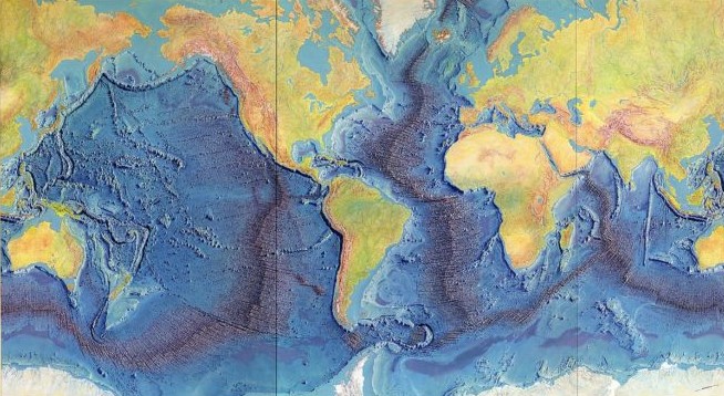
With advances in technology, especially during World War II, more clues to the earth’s geologic history were unearthed. Scientists were better able to map and study the ocean floor and discovered the presence of an underwater mountain range chain called the mid-ocean ridge system and deep-sea trenches. They also discovered that the ocean floor is not as old as expected and that the magnetic properties of the ocean sediment alternate in a matching pattern on either side of a mid-ocean ridge. These discoveries led geologist Harry Hess to develop his seafloor spreading theory. According to this theory, the mid-ocean ridges are spots where the earth’s crust is weak, allowing magma from the earth’s mantle to come up to the surface and create new seafloor. Deep-sea trenches are areas where old seafloor is being driven back into the mantle. Further research found that earthquakes and volcanic activity are concentrated near ridges and trenches. The clues all led to the modern day theory of plate tectonics.
To understand plate tectonics, we must first look at the make-up of the earth. The earth is divided into three main layers:
- core – made of dense metals, the inner core is solid and the outer core is liquid
- mantle – a thick layer of semi-solid molten rock surrounding the core
- crust – the thin, hard outer layer broken into different slabs or plates
The semi-solid mantle moves in a circular motion, pulling the overlying crustal plates with it. The mantle’s circular motion comes from two sources. First, heat from within the earth warms the mantle material, causing it to rise toward the crust. Near the crust, the mantle material cools and sinks down toward the core. The second force impacts the mantle at deep sea trenches. The heavy crustal plate is pulled by gravity down into the mantle dragging mantle material with it (this is called “slab pull”). Due to this convection motion in the mantle, the large plates covering the earth’s surface are constantly moving. The boundaries between these moving plates are very active areas. The plate boundaries can be one of four types:
- divergent – moving away from one another (mid-ocean ridges)
- convergent – moving toward one another (trenches)
- transform – slipping past one another (faults)
- boundary zones – complex areas with several interacting plates
Data Activity
In this activity students will use data from underwater earthquakes to deduce the location of plate boundaries.
- Divide class into pairs or small groups. Print a copy of the world map for each group.
- Download the ocean seismicity map based on USGS data showing major earthquakes from 1900-2017.
- Using the location of seismic activity (underwater earthquakes) from the NOAA data, ask your students to outline on the world map where they believe the relevant plate boundaries are. When they are finished, compare to the USGS’s map of the plates and discuss. Did the students’ plate boundaries align with those of the USGS? Ask them to finish sketching and label the relevant plates. Were there areas with earthquakes but no plate boundaries?
Given Earth’s geological history, do you think there will ever be another supercontinent like Pangaea? Why or why not?
How can understanding plate tectonics help us predict and mitigate natural disasters such as earthquakes and tsunamis?